To find geopolitical shifts and actions across the world, one often needs to do what is fundamental in any situation.
Follow the money.
Usually, the larger geopolitical decisions and actions are never taken with a view to nationalism or any great moral standing. They are a manifestation of economic interests.
After all, wars and aggressive stands need investments. Investments come with the profit interests built-in. No profit, no war.
Controlling the water, land and air routes is the key to owning the trade flow around the world.
Supply Chain, as the experts like to call it.
Managing supply chains are the key to trade.
That is where the primacy of the Indian Ocean Region comes in.
This is where the future of the world will be decided.
Indo-Pacific Region and India's Maritime transformation
Japan, the US, India, and Australia met in Tokyo this month in a Quad Summit. Their focus - was the Indo-Pacific region.
In a joint statement from the Quad summit hosted by Japan in May 2022, the leaders of the United States, Australia, India, and Japan reemphasized the principles of a free and open Indo-Pacific: freedom, rule of law, democratic values, sovereignty, and territorial integrity. The meeting also appeared to reinforce a central purpose of the Quad—to provide the region with public goods. (Source)
Why is the Indo-Pacific region so crucial to all?
To understand this, we will need to look at many geopolitical factors and players. Let us start with how India's maritime vision and perspectives have been changing.
India's Integrated Headquarters published a strategic document in 2015 titled Ensuring Secure Seas: Indian Maritime Security Strategy (also called IMSS-2015 or Strategy-2015). It shared the new Indian mindset and thinking relative to the naval operations, direction, and strategic perspective.
The previous version of the strategy published in 2007 was titled "Freedom to Use the Seas: India’s Maritime Military Strategy."
The change in tone of the executive and military thinking is obvious from the titles themselves. While the 2007 document was seeking permission to "use the seas", the 2015 document took ownership of the Indian ocean and other seas such that the Navy was ready to "ensure secure seas".
For those who want to read the 2015 document, you can download from here.
India's foreign ministry has its work cut out. One should seriously watch and listen to what Dr. Jaishankar has to say along with others on the Indo-Pacific Region. Remarks by H.E. Josep Borrell Fontelles, (High Representative of the European Union for Foreign Affairs and Security Policy and Vice President of the European Commission for a Stronger Europe in the World) are also extremely interesting.
India is the world's 16th largest maritime country with a coastline of 7,517 kilometers long, with 12 major and 205 notified minor and intermediate ports (Source).
Over the last few years, the Indian government has invested a lot of money into the entire maritime capability of India.
The flagship Sagarmala project, however, was started in July 2015. The aim was to improve the logistics infrastructure by modernizing and building new ports.
By 2022, 7 years later, the progress has been fairly substantial.
The Minister said the report card of Ministry showcases 802 projects worth Rs. 5.48 lakh crore under the Sagarmala program targeted to be executed by 2035 out of which 194 projects worth Rs. 99,000 Crore have been completed. (Source: Live Mint)
And, the government is confident that Rs 2.12 trillion worth of projects will be completed by 2024.
The question however would be how has all this investment really impacted things "on the ground"?
With the central government’s push towards port-led infrastructure development and de-congestion at major ports, the turnaround time at major ports has been reduced to 26.58 hours. The number is significantly down from over 44 hours in the financial year 2013-14, and slightly less than 27.38 hours in the last fiscal year, the minister said. (Source: Business Standard)
From 44.70 hours to the now 26.58 hours means that the turnaround time for the ships is down by 41% in 7 years. And this time has been steadily falling every year.
That is the logistics from the Indian perspective.
But the Indian Ocean, which is at the heart of the Indian naval operations is strategically critical for the world trade itself.
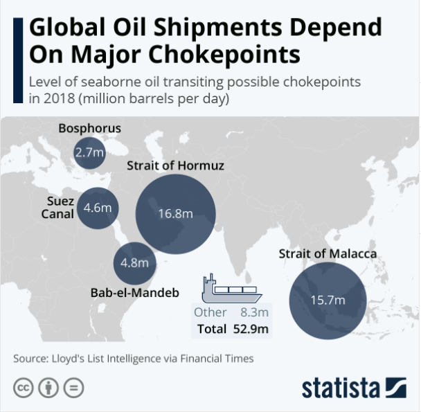
The Indian Ocean is important for three reasons. First, it enjoys a privileged location at the crossroads of global trade, connecting the major engines of the international economy in the Northern Atlantic and Asia-Pacific. This is particularly important in an era in which global shipping has burgeoned. Today, the almost 90,000 vessels in the world’s commercial fleet transport 9.84 billion tonnes per year. This represents an almost four-fold increase in the volume of commercial shipping since 1970.[1] The energy flows through the Indian Ocean are of particular consequence. Some 36 million barrels per day—equivalent to about 40 per cent of the world’s oil supply and 64 per cent of oil trade—travel through the entryways into and out of the Indian Ocean, including the Straits of Malacca and Hormuz and the Bab-el-Mandeb.[2] (Source: Brookings)
So, one thing is fairly obvious - trade-wise, the Indian Ocean is very critical to the world.
On March 12, 2015 the Indian PM Narendra Modi discussed the concept of SAGAR (Ocean in Hindi/Sanskrit) which he shared as Security and Growth for All in the Region. It was the vision and geopolitical framework that India under Modi would follow in the overall area of maritime cooperation within the Indian Ocean Region (IOR). (Source) Here are some key points related to mission SAGAR.
- India’s strategic strategy for the Indian Ocean, titled “Security and Growth for All in the Region," was announced in 2015. The vision assumes significance in current times as it is becoming increasingly apparent that marine security, maritime commons, and cooperation are of utmost importance to nations’ security and economic aspirations
- India’s goal with SAGAR is to strengthen economic and security connections with its maritime neighbors while also assisting in the development of its maritime security capabilities. For this, India would collaborate on information sharing, coastline surveillance, infrastructure development, and capability enhancement.
- India also wants to protect its national interests and ensure that the Indian Ocean region becomes more open, collaborative, and respectful of international law.
- The vision is important for the country to leverage the blue economy. The blue economy offers India a once-in-a-lifetime opportunity to achieve its national socioeconomic goals (job creation, energy security, environmental resilience, and so on) while also improving connections with its neighbors.
- The vision also holds importance amid China’s increasing assertiveness and influence in the Indian Ocean region through its maritime silk route, which is part of the BRI program. Furthermore, Chinese investments in India’s neighbors are dual in nature, with both commercial and military underpinnings. India’s strategic worries have been raised by the string of pearls.
- Launched in May 2020, Mission Sagar, under the Vision SAGAR was India’s initiative to deliver Covid-19 related assistance to the countries in the Indian Ocean region. As part of this Mission, INS Kesari successively visited Maldives, Mauritius, Madagascar, Comoros, and Seychelles to deliver assistance to our maritime neighbors in dealing with the Covid crisis. India’s humanitarian assistance included supplies of essential food items, medicines, Ayurvedic medicines, and deployment of Medical Assistance Teams (MAT) to Mauritius and Comoros. The Mission was launched to engage with countries in the Indian Ocean Region, in line with the PM’s vision of SAGAR.
As India's geopolitical framework changed from Look East Policy to Act East Policy, the way India's security vision was to be defined also changed.
One of the important ingredients of that Act East policy was the understanding and intention to fight the aggressive Chinese advancements around India and its neighborhood.
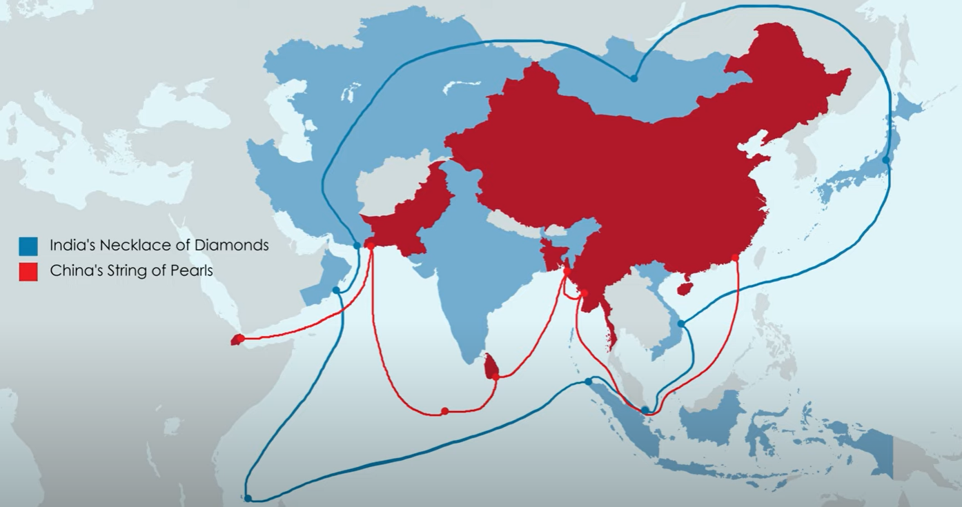
Of Pearls and Diamonds - the ornamental game of geopolitics
Chinese strategy to encircle India and create an aggressive posture in the maritime world was called the "String of Pearls".
Using its now infamous "Debt Trap Diplomacy", the Chinese establishment was creating assets of dual use for itself. From Doraleh multipurpose port in Djibouti, Gwadar & Karachi Deepwater port in Pakistan, Hambantota and CICT Terminal in Srilanka, to Kyaukpyu port in Myanmar, China had captured the strategic port bases.
China wanted to increase its presence and ability to impact the important trade routes in the IOR and also have the ability to dictate situations at major maritime chokepoints like the Strait of Mandeb, the Strait of Malacca, the Strait of Hormuz, and the Lombok Strait.
India, under Narendra Modi, had its own answer - the "Necklace of Diamonds".
In 2004, US defence contractor Booz Allen Hamilton, in a report titled ‘Energy Futures in Asia’, had used the term “String of Pearls” to describe China’s strategy to expand its naval presence throughout the Indian Ocean Region (IOR) through built-up of civil maritime infrastructure. Since then, there has been much speculation and debate surrounding the validity, extent and potential intentions behind the concept. At the same time, Chinese officials have consistently denounced “the so called ‘string of pearls’ construct” as a motivated distortion of their regular economic engagements. The phrase ‘necklace of diamonds’ was first mentioned by India’s former Foreign Secretary Lalit Mansingh while speaking at a think tank in August 2011 on ‘India’s Regional Strategic Priorities’. He had argued that “India is doing everything it is supposed to do in terms of protecting its interests. To the doctrine of the String of Pearls, India has its own doctrine, the Necklace of Diamonds. Just as the Chinese are building port facilities, we are tying up naval cooperation with almost all the major powers of the Indian Ocean region.” Even though commentators often use ‘necklace of diamonds’ to describe India’s strategic approach to counter China’s growing influence in the IOR, it has not found any mention in the Government of India’s official discourse. (Source: Manohar Parrikar Institute for Defence Studies and Analyses (MP-IDSA))
The Necklace of Diamonds is India's way to take back control of the Indian Ocean Region and put a stamp on its neighborhood.
The strategy includes a combination of both, creating strategic bases in the region as well as fostering strategic cooperation with other nations.
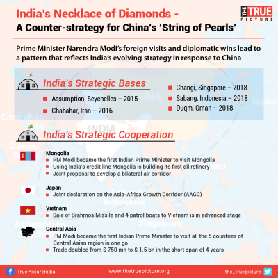
SO when we look at the Chinese strategy of the "String of Pearls" and Modi's counter of "Necklace of Diamonds" one finds that the Chinese encircling of India was met by a larger encircling of the Chinese circle in a more aggressive and permanent manner.
We had discussed many aspects of this geopolitical game being played out between India and China.
 Desh Kapoor
The elephant in the geopolitical room between India and China - is the Strait of Malacca. Why? Let us look at it.
Strait of Malacca - the elephant in the geopolitical IOR room
A 930 km long, and running as narrow as 38 km with waters 82 ft deep, this stretch of the ocean between the Malay peninsula and Indonesia's Sumatra island is one of the busiest trade routes in the world! After all, it is the shortest conduit between the Pacific Ocean and the Indian Ocean.
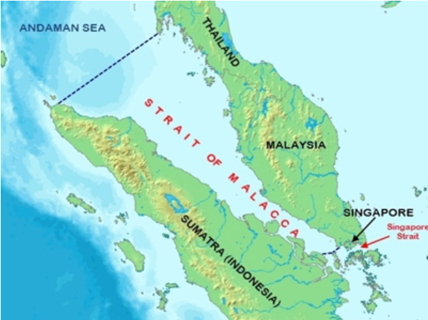
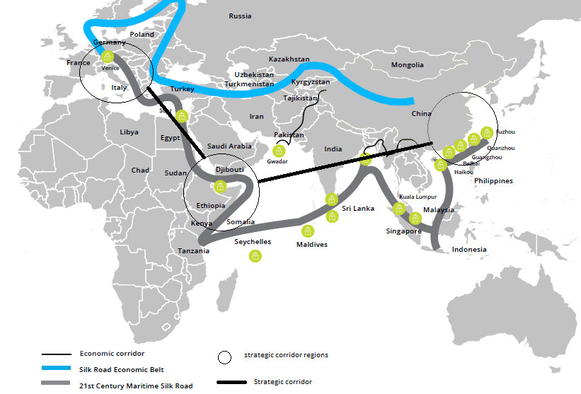
It is the critical component of the overall Maritime Silk Road that connects the Chinese coast towards the southern tip of India to Mombasa, from there through the Red Sea via the Suez Canal to the Mediterranean, there to the Upper Adriatic region to the northern Italian hub of Trieste with its rail connections to Central Europe and the North Sea
The Maritime Silk Road is the modern 21st-century version of what was known as the "Silk Road" back in history that enabled trade between Asia and Europe.
Coming back to the Strait of Malacca.
It is a narrow piece of channel that indeed carries a huge maritime burden and is one of the most significant choke-points for Chinese trade.
The 900-km long (550 miles) Malacca Strait links Asia with the Middle East and Europe, carrying about 40 percent of the world’s trade. More than 50,000 merchant ships ply the waterway every year. About 3.3 million barrels per day (bpd) of Middle East crude passed through the strait and to Japan last year. Middle East crude accounts for 90 percent of Japan’s total imports. (Source)
A quarter of the world's oil shipments pass through the Strait of Malacca, second only after the Strait of Hormuz.
The Strait of Malacca's importance is obvious in commercial and military terms.
It is China's biggest geopolitical headache as well.
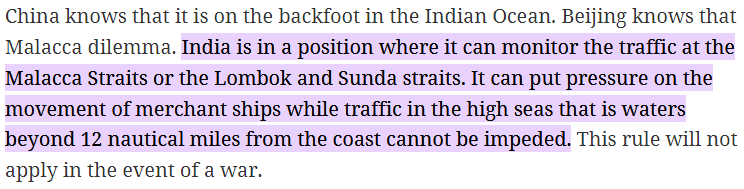
China's Malacca Dilemma
The term "Malacca Dilemma" was coined in 2003 by the then Chinese President Hu Jintao.
 Old Writer
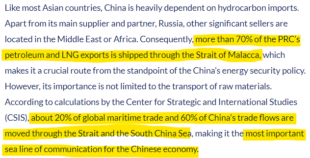
70% of China's petroleum and LNG exports and 60% of China's trade flows go through the Strait of Malacca. Making it China's lifeline.
In terms of the Sea Lines of communication (SLOCs), China has a major issue.
Read this post from Drishtikone's archives on the investments made by India in the ports around the region.
Desh Kapoor
And central to China's Malacca Dilemma is that India sits at the mouth of the Strait.
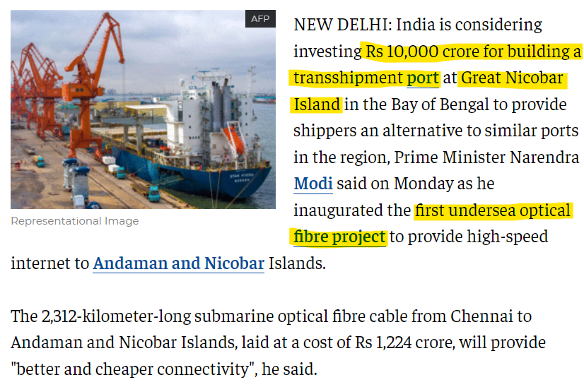
An Indian naval air station under the joint-services Andaman and Nicobar Command (ANC) of the Indian Armed Forces is located near Campbell Bay. This is on Great Nicobar island in the Andaman & Nicobar Islands. Recently it is being expanded.

A deepwater port is being built at Great Nicobar Island at a cost of US $ 1.3 billion (Source).
Where is this Campbell Bay Naval base? Here check it out on the Google Map.
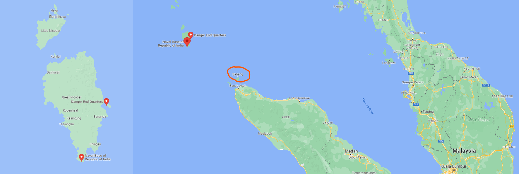
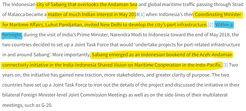
That Sabang port that is marked out on the map? That is another place where the Modi government has made investments.
In fact in what is being seen as the Aceh-Andaman connectivity initiative, the Indian and the Indonesian governments have forged an alliance that can have critical control over the Strait of Malacca.
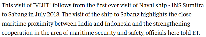
After May 2018 initiative by India in Sabang, the Indian Navy followed it up with the first-ever Navy ship visit by INS Sumitra in July 2018.
In March 2019, the Indian Coast Guard ship Vijit visited Sabang as well.
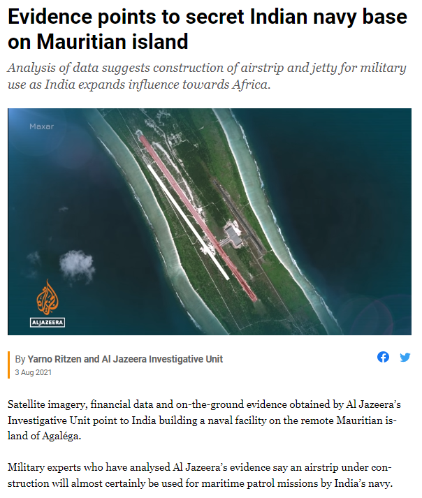
The Agaléga secret
In 2021, Al Jazeera - surely with the backing and funding of other 'forces' that are competitive against India - shared an investigative report where they said that India was creating a naval base on Agaléga, an island of Mauritius.
The melodramatic tone of the video notwithstanding here is a video of the "investigation" that AlJazeera did.
In 2018, Economist Intelligent Unit (EIU) report discussed this as well.
Both countries had until recently remained silent on the specifics of the agreement. In May 2018 the Mauritian government told parliament that the deal was subject to a confidentiality agreement, most probably because they did not want political tensions with the opposition to increase. The opposition's main concern is the potential militarisation of Agaléga, or worse, the loss of these islands to India. On October 25th however, Mauritius's prime minister, Pravind Jugnauth, said that India had contracted the US$87m project to an Indian company, and that it would be financed through an Indian grant. Mr Jugnauth also confirmed that India would be allowed to use the port facilities once they are in place. Once renovated, the Agaléga airport is likely to become a hub for India's naval operations in the Indian Ocean. The work on the runway, which will be extended by 3 km, and on port facilities, which will have transponder systems, is expected to begin in February 2019. (Source: Economist)
So India's investments have been growing in the ports and possible bases in the Indian Ocean region.
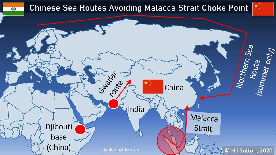
China's Options and Issues
Indian intent is clear - control the Strait of Malacca and have strong leverage against China.
So what does China do? It looks for alternatives. Such as China Pakistan Economic Corridor (CPEC) with Gwadar as its port and the other side of the oceans - the Northern Sea Route.
These two seem logical.
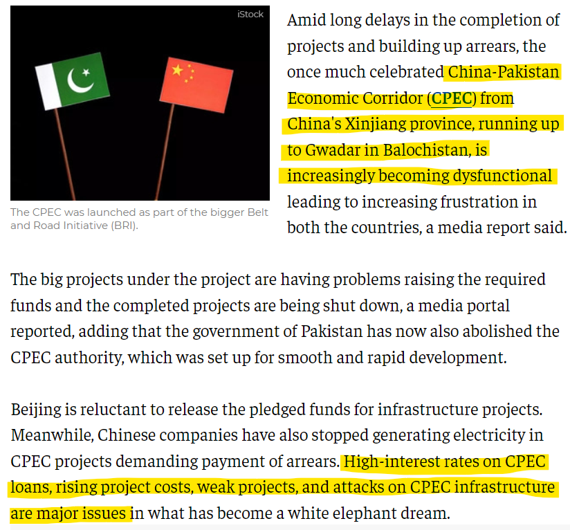
CPEC - fan-fare and reality
It was launched amidst great fan-fare a few years back. In Pakistan, it was being hailed as the greatest panacea for all its problems.
One such option is Gwadar Port in Pakistan. As part of the China Pakistan Economic Corridor (CPEC), Beijing has developed the port in Gwadar so that goods unloaded there will be shipped overland to China. On June 8 the Pakistani government approved a $7.2bn upgrade to a railway which will connect Gwadar to Kashgar, China. The port is not yet operating at capacity, but the direction seems clear. (Source: "India can ‘no longer’ choke China at the Strait Of Malacca as Beijing finds solution" Eurasiantimes)
However, over the years, the entire CPEC initiative has run into serious issues and is almost dysfunctional.
This is further complicated due to the emerging Balochistan self-determination movement.
First, let us understand that Pakistan is primarily run by the Punjabi military-bureaucracy nexus. And this nexus has ensured the political exclusion of every other region. But Balochistan, which was annexed by Pakistan by force, has also been marked by resource exploitation because of its minerals. The way CPEC has been functioning in connivance with the Pakistani establishment, it has led to the exclusion of Baloch firms, labor, and native fishermen from the whole process.
Pakistan has always carried out its violent campaign against the Balochis for many decades. Recently, however, two incidents stand out. Deaths of Karima Baloch and Sajid Hussain.
The sudden disappearance and the subsequent death in Canada of 35-year-old Karima Baloch, one of the popular leaders of the Balochistan freedom movement, does come as a shock, though not as a surprise. She was on the hit list of the Inter-Services Intelligence (ISI) for quite some time and had aired her fears about being targeted by the Pakistani military for speaking up against it. This is not the first time that a high-profile anti-Islamabad Baloch leader has met Karima’s fate. In March this year, Baloch journalist Sajid Hussain was found dead in the Fyris River near Uppsala in Sweden. He was the editor of Balochistan Times, a news website covering human rights violations, forced disappearances, and the drug trafficking menace in Pakistan. Although the Swedish police closed the case as “probable suicide or accidental death,” the Paris-based Reporters Without Borders (RSF) had alleged that it was a hit job by Pakistan’s ISI and the Military Intelligence (MI) wing of the Pakistan army. (Source)
The continued repression and violent treatment of the Balochis, along with their marginalization has led to an insurgent movement in Balochistan and the rest of Pakistan by the Balochis. The attacks by the Balochi freedom fighters on the Chinese interests and people have been on the rise.
In August 2021, a suicide bombing targeting Chinese nationals at the East Bay Road in the port of Gwadar was carried out by the Balochistan Liberation Army (Source).
Then in April 2022, another suicide bombing killed 3 Chinese nationals when a woman operative of the Baloch Liberation Army blew herself up at the University of Karachi.

All this has led to two things:
- Economically unstable and unviable investment by China, which has led Pakistan into a debt trap
- Increasing attacks by Balochis make the whole CPEC unsustainable
Therefore, the new government of Shehbaz Sharif has scrapped the China-Pakistan Economic Corridor (CPEC) Authority.
Pakistan's new government has initiated a process to abolish the China-Pakistan Economic Corridor Authority, with the planning minister saying it was a "redundant organisation" that wasted resources and thwarted speedy implementation of the ambitious regional connectivity programme. Planning Minister Ahsan Iqbal passed orders to the concerned officials to begin the process of abolition of the authority following reports that Chinese power producers have shut down 1,980 megawatts of production capacity due to non-clearance of their Rs300 billion dues, The Express Tribune newspaper reported. The China-Pakistan Economic Corridor (CPEC) Authority established through an ordinance in 2019 was aimed at accelerating the pace of CPEC-related activities, finding new drivers of growth, unlocking the potential of interlinked production networks and global value chains through regional and global connectivity. According to the newly appointed planning minister, his officials "will move a summary seeking Prime Minister Shehbaz Sharif's approval to abolish the CPEC Authority". (Source: News18)
This route as an alternative to the Strait of Malacca is well-nigh buried now.
Arctic Route alternative
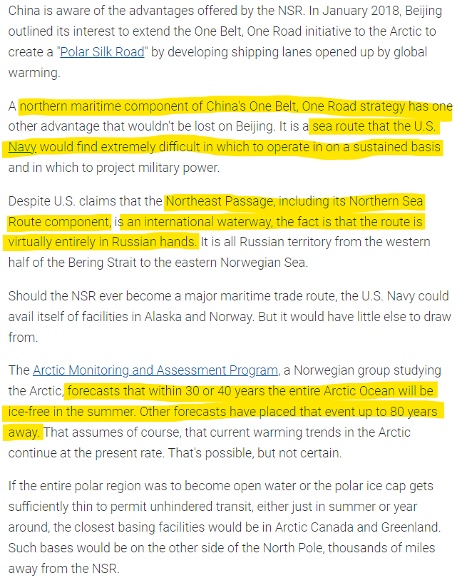
Another alternative that China is looking at is the "Polar Silk Road". China articulated its Arctic Policy in January 2018. (Source)
China will construct a “Polar Silk Road” and actively participate in the development of Arctic and Antarctic regions, it said in its new 2021-2025 “five-year plan” published on Friday. The plan said China would “participate in pragmatic cooperation in the North Pole” and “raise its ability to participate in the protection and utilisation of the South Pole”. China has been eyeing lucrative mineral resources as well as potential new shipping routes in Arctic regions, as ice caps recede as a result of rising temperatures. (Source: Reuters)
The entire Arctic policy has two-fold objectives.
One, exploit the natural resources. The area has roughly 13 percent of the world’s undiscovered crude oil and 30 percent of undiscovered natural gas. (Source) As the global warming makes it easier to access these minerals, the race to own a piece of the pie in Arctic is on. Chinese has a long-term stake in the Russian Yamal Liquified Natural Gas (LNG) project
Two, the shipping route - the Polar Silk Road.
The two primary paths, the Northwest Passage (NWP) and Northeast Passage (NEP), provide faster alternatives to direct European and North American energy goods to China, shaving weeks off popular routes such as those out of Rotterdam. A third Arctic passage, the Transpolar Sea Route, cuts through the Arctic between the NWP and NEP through international waters but can only be accessed by the heaviest icebreaker ships. In general, the reduced shipping times would mean lower fuel costs and emissions. However, with the exception of the North Sea Route portion of the NEP, the majority of Arctic routes have poor infrastructure and search and rescue capabilities. Other barriers, such as increased insurance premiums and variable seasonal conditions, may deter increased volumes of trade through these routes until decades later. (Source: Center for Strategic and International Studies)
The Northeast Passage (NEP) is the alternative trade route that runs through the Russian Exclusive Economic Zone that circumvents the Strait of Malacca issue.
The only issue is that scientific studies are putting the time when the traffic across the Northwest Passage may take many decades.
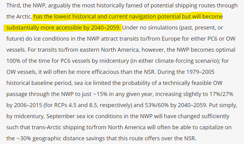
However, the scientists are saying that in another 30-40 years, the entire Arctic Ocean will be ice-free in summers. That means the northern sea route would be a viable alternative to the Indian Ocean.
The Chinese idea is good but it will be tough to implement.
China obviously has its work cut out because in both the areas - the Indian Ocean and the Arctic route, its trade and future prosperity can be easily throttled by other powers - India and Russia, respectively.
Now, do we get a better context on the whole Russia Vs US/Europe and Russia-Chinese closeness and the underlying context of India's reluctance to go against Russia, specifically Putin scenarios?
Video corner: Subterranean forests of Guangxi
Recently discoverers came across an unbelievable find.
Underground forests in a sinkhole in Guangxi, China. Huge trees are growing there.
An ancient forest has been found at the bottom of a giant sinkhole in China, with trees up to 40 metres (130ft) tall. Scientists believe it could contain undiscovered plant and animal species. Cave explorers in the Guangxi region of southern China alerted scientists when they found the sinkhole, which had a primitive forest inside. Among 30 sinkholes in Leye County this is the largest, at 306 metres long, 150 metres wide and 192 metres deep. (Source)
Here is a video of its exploration.
If you like our content and value the work that we are doing, please do consider contributing to our expenses. CHOOSE THE USD EQUIVALENT AMOUNT you are comfortable with.
If you like this post - please share it with someone who will appreciate the information shared in this edition.
Today’s ONLINE PAPER: Check out today’s “The Drishtikone Daily” edition. - THE DRISHTIKONE DAILY